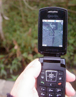
If you have a newish mobile phone, with net access and the ability to run java applications you can get google maps on your phone. Being google maps (as opposed to flickr's yahoo maps) local detail and the related satellite imagery for Australia is pretty good. In the town you can get down to street level, no worries. It is basically designed to help you find things (like business) However it is off the beaten track that geotagging photographers will find the google maps satellite images impressive, not quiet as good as a GPS but with a little practise I'm sure most of use will be able to get our photographic locations within at least a few 100 meters AND it is easy to save these locations as placemarkers in favourites (pressing the * key will redisplay them) BUT I haven't figured out how to merge the location details into my cameras EXIF data, well yet!
If you are interested, enter the following URL into your phone's browser -
www.google.com/gmm
It will initially download the 129kb of software then guide you into the maps.

See where this picture was taken. [?]
Small Warning: Zooming and panning satellite photos can involves serious amounts of data downloading, so check your phone contract before you start and get too enthusiastic, to make sure it is not too expensive!
PS: Seems I have not checked yahoo maps, via flickr, recently enough; the resolution in melbourne was improved a dramatically (it needed too)
No comments:
Post a Comment